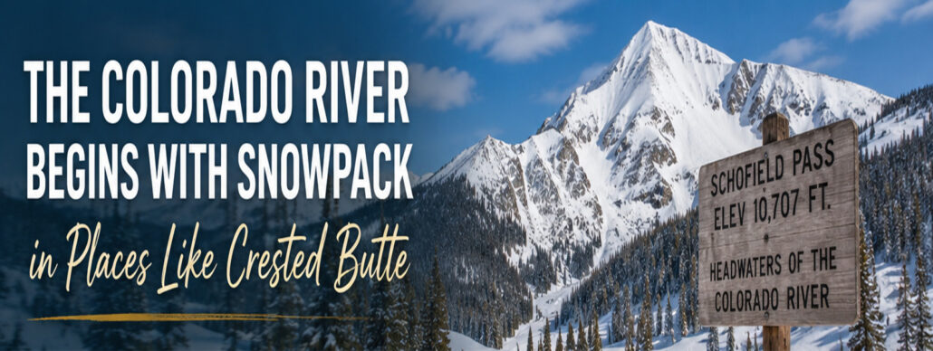
The Colorado River Begins with Snowpack in Places Like Crested Butte – In late March, I attended a Colorado River presentation by the Upper Gunnison River Water Conservancy District. One of the speakers, Sonja Chavez is the General Manager of the Upper Gunnison River Water Conservancy District (UGRWCD) in Gunnison, Colorado. She is also a water resources expert, a native Coloradan with a ranching heritage, and currently serves as a board member for the Colorado River District.
She walked through the current state of the Crested Butte snowpack – and the Colorado River system, reservoir levels, and the increasingly tense negotiations happening between the seven Colorado River states.
 Everyone in the room was attentive.
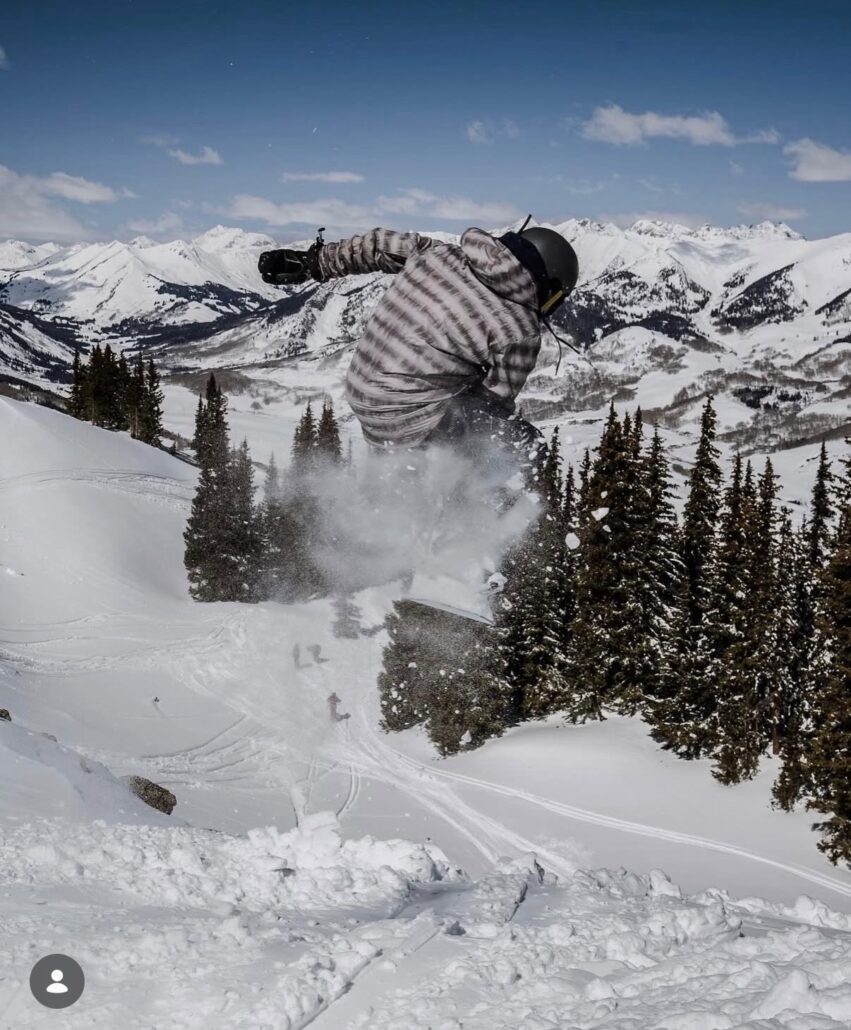
Because people in Crested Butte understand – we are a mountain ski resort town. Snowpack = skiing, and the connection between amount of snowpack and summer water levels are key to our mountain lifestyle… and the Colorado River starts in mountain towns like Crested Butte.
The snow falling on Schofield Pass, Kebler Pass, Red Mountain, and the Elk Mountains eventually serves roughly 40 million people downstream, and it irrigates farmland, supports reservoirs, powers economies, and provides drinking water.
The Crested Butte Headwaters – Our snowpacked mountains feed into the Slate River and East River in Crested Butte – flowing downstream they join the Taylor River and become the Gunnison River. The Gunnison River flows into the Blue Mesa Reservoir, then the Morrow Point Reservoir, then the Crystal Reservoir, finally flowing freely through the Black Canyon, then the Gunnison Gorge, and then flows into the Colorado River.
And this year, we didn’t get much snow here in Crested Butte – and throughout the West.
That was not new news for anyone in the room, because for the people who live in mountain towns on Colorado’s Western Slope, water isn’t an abstract environmental issue. It’s deeply personal.
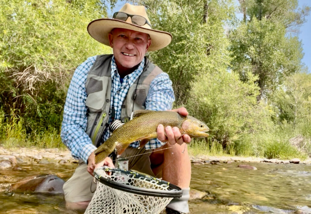
Rivers and streams provide recreation for locals and visitors – we fly fish, paddle, float and use water in the rivers.
Irrigation ditches deliver water to local ranches for hay and livestock.
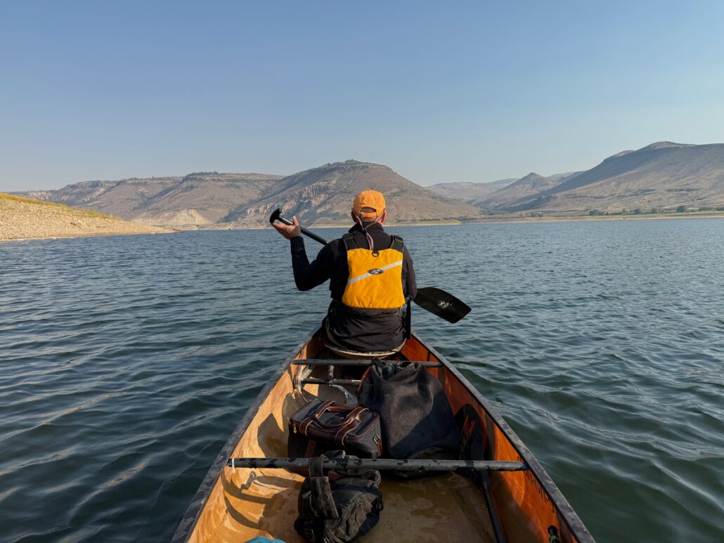
Lakes and reservoirs – Long Lake, Meridian Lake, Grant Lake, Taylor Reservoir and Blue Mesa reservoirs hold water, for recreation – fishing, and provide boating, swimming, fishing.
Groundwater wells and springs provide water for residential and commercial use and sustain us all.
A Bad Snow Year in the Headwaters
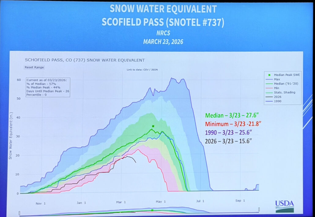
One of the more sobering charts presented showed snow-water equivalent measurements from the USDA SNOTEL station at Schofield Pass.
On March 23, the 2026 snowpack measured only 15.6 inches of snow-water equivalent compared to a median of 27.6 inches.
That’s roughly 57% of normal.
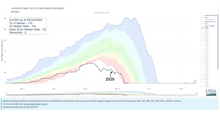
See Current Schofield Pass Chart as of May 20, 2026
We don’t need a chart to know it was a strange winter.
The snow never really stacked up the way it normally does. Warm storms, dry stretches, and early melt patterns became the story of the season. Hillsides started appearing early. South-facing terrain looked like late April while the calendar still said March.
But the numbers matter because snowpack in the Upper Colorado River Basin functions like a giant natural reservoir.
Less snow means less powder days and extreme skiing in the winter and also summer implications:
- less runoff
- lower stream flows
- warmer rivers
- increased wildfire risk
- more pressure on downstream water users
And when the Colorado River system is already under historic strain, a weak snow year in the headwaters becomes a much bigger deal.
The Seven States Still Can’t Agree
The Colorado River is governed by an incredibly complicated system of laws, agreements, and allocations often referred to as the “Law of the River.”
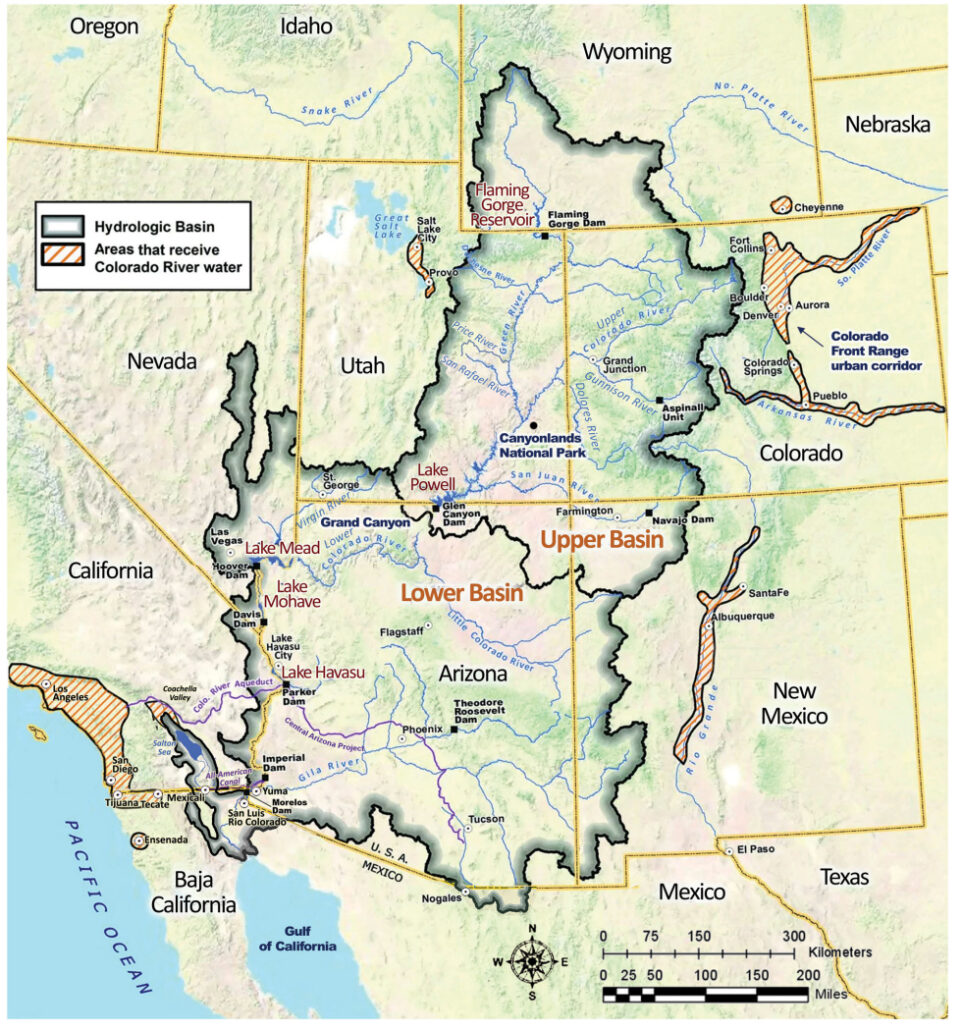
The seven basin states are:
Upper Basin
- Colorado
- Wyoming
- Utah
- New Mexico
Lower Basin
- California
- Arizona
- Nevada
The conflict today is fairly simple:
The river was divided up over 100 years ago using water-flow estimates that turned out to be overly optimistic.
In other words, the states allocated more water than the river consistently produces.
For decades, giant reservoirs like Lake Powell and Lake Mead helped mask the problem.
Now they can’t.
Reservoirs across the system remain dramatically below historical levels after years of drought, warming temperatures, and over-allocation. Meanwhile, the seven states still cannot fully agree on how future shortages should be handled.
And tensions are rising.
Upper Basin states argue they are already dealing with hydrologic shortages because they physically receive less water in dry years.
Lower Basin states — particularly California and Arizona — rely heavily on guaranteed deliveries that support massive agricultural economies and rapidly growing urban populations.
Everyone wants certainty.
But the river no longer provides enough water for everyone to keep using it the way they historically have.
That’s the uncomfortable truth underneath all the negotiations.
The Part Most People Don’t Understand About Water Use
When people think about water shortages, they usually picture long showers, lawns, golf courses, or suburban sprinkler systems.
Those things matter.
But they are not the primary driver of Colorado River consumption.
Agriculture is.
Depending on the study, roughly 70% to 80% of Colorado River water is used for agriculture.
And one of the largest single uses is cattle-feed production — particularly alfalfa and hay.
That surprises a lot of people.
Especially when you start looking at water footprints.
A pound of strawberries may require less than 50 gallons of water to produce.
A pound of almonds? Roughly 1,900 gallons.
That number sounds almost absurd until you realize how much agriculture exists in extremely arid regions dependent on imported river water.
None of this means agriculture is “bad.”
Farmers and ranchers are essential to the West.
But it does mean the math becomes difficult when water supplies shrink while demand continues growing.
And the math on the Colorado River is getting tighter every year.
“A pound of strawberries may require less than 50 gallons of water to produce. A pound of almonds? Roughly 1,900 gallons.”
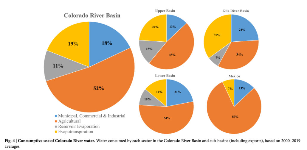
Overall Colorado River Basin-Wide Water Usage Breakdown
Agriculture (Irrigated Crops): ~52% of total water consumed (and over 74% of direct human usage).
MCI (Municipal, Commercial, Industrial): ~15% to 18% of total usage.
Reservoir Evaporation / Environmental Losses: ~19% of the river’s total volume.
State-by-State Profiles of Water Usage (Direct Human Use)
California (Largest Consumer – ~4.4 MAF Allocated)
Agriculture: Over 80% of California’s Colorado River water goes strictly to agriculture, primarily in the Imperial and Coachella Valleys to grow alfalfa, hay, and winter vegetables.
Municipal/Industrial: ~20% goes to municipal use, largely serving the Metropolitan Water District of Southern California (Los Angeles/San Diego).
Arizona (~2.8 MAF Allocated)
Agriculture: Roughly 70%–75% is used for agriculture (cotton, alfalfa, grains).
Municipal/Industrial: ~25%–30% feeds the Central Arizona Project, supplying the fast-growing municipal and commercial sectors of Phoenix and Tucson.
Colorado (~3.8 MAF Upper Basin Allocation)
Agriculture: Close to 85% of the water utilized within the state goes to cattle feed and livestock agriculture on the Western Slope.
Municipal/Industrial: ~15% is diverted via trans-mountain tunnels under the Continental Divide to supply municipal and industrial needs for the Front Range (Denver, Colorado Springs).
Utah (~1.7 MAF Upper Basin Allocation)
Agriculture: Over 80% goes toward agricultural irrigation, dominated by alfalfa and pasture feed.
Municipal/Industrial: ~15%–20% is utilized for residential/commercial expansion, particularly in southern areas like St. George and parts of the Wasatch Front.
Nevada (Smallest Consumer – 0.3 MAF Allocated)
Municipal/Industrial: Unlike every other state, Nevada uses nearly 100% of its allocation for Municipal, Commercial, and Industrial purposes, specifically to pump water to Las Vegas. Because they return nearly 40% of their indoor water back to Lake Mead via treated wastewater return flows, their net consumptive footprint is highly optimized for urban use.
 The New Reality Water Usage Downstream Must Change
There’s no question the Colorado River system is under pressure.
There also seems to be little doubt that downstream usage patterns are going to have to change over time. You simply can’t continue allocating more water than the river consistently produces and expect the math to work forever.
 At the same time, people in the West have been dealing with drought cycles for generations.
There have been dry years before.
There will be dry years again.
Living in the headwaters, we experience these cycles differently than downstream cities do. Communities like Crested Butte don’t have a major impact on overall Colorado River consumption, but we do get to enjoy one of the most spectacular environments anywhere in the American West.
That’s one of the things I was reminded of during the Upper Gunnison River Water Conservancy District presentation in late March.
When you live in a high-altitude mountain town like Crested Butte, you become connected to water in a very direct way. Snowpack matters here. Rivers matter here. Healthy forests matter here.
But so does quality of life.
Even in a lower snow year, we still get to enjoy incredible skiing in the winter, world-class fly fishing and mountain biking in the summer, beautiful public lands, cool mountain temperatures, and a lifestyle that’s becoming harder and harder to find elsewhere.
That’s one reason so many people continue investing in mountain communities on Colorado’s Western Slope.
The Colorado River negotiations will continue. Policies will evolve. Water usage downstream will almost certainly need to become more efficient over time.
But life in Crested Butte continues to revolve around the same things it always has — mountains, rivers, recreation, ranching, community, and access to an outdoor lifestyle that’s difficult to replicate anywhere else.
And honestly, that’s a pretty great place to be.
If I can help you in any way with your Crested Butte real estate search — whether you’re looking for a ski property, summer retreat, investment opportunity, or simply trying to better understand the market here on the Western Slope — feel free to reach out anytime.
How is the Crested Butte Real Estate Market doing?
The Crested Butte Real Estate Market is very active. Get Your Monthly Crested Butte Real Estate Market Reports.
Whether you are a current Second Homeowner or You are Considering Buying Real Estate in Crested Butte – this detailed Monthly Market Report will save you Time and Help YOU make informed decisions.
Get Your Crested Butte Real Estate Market Report Now!

I appreciate the opportunity to earn your business and be your Crested Butte Real Estate Agent.
Contact me at:
Chris Kopf
Global Luxury Property Specialist
Coldwell Banker Mountain Properties
Chris.Kopf@CBMP.com
(970) 209-5405
ChrisKopfCB.com